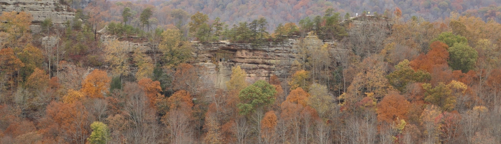

Featured Image: Late fall view looking across the valley from Auxier Ridge to Double Arch
For you shall go out in joy and be led forth in peace; the mountains and the hills before you shall break forth into singing, and all the trees of the field shall clap their hands. ~Isaiah 55:12 (ESV)
Red River Gorge – A Beautiful Little Corner of God’s Creation
My wife and I have been hiking and backpacking in Kentucky’s Red River Gorge for over fifteen years; and, while we have traveled great distances to some pretty spectacular places, two factors put Red River Gorge at the top of our list of favorite hiking destinations. First, and foremost, is the sheer beauty of the gorge. No matter what time of year we have visited, even in winter, the scenery is amazing. And, with the variety of landscapes, from towering cliffs and ridges offering panoramic views, to lush, forested valleys with tumbling streams, water falls, and rock shelters, to the numerous, incredible arches, there are no limits to the natural wonders to be explored in this magnificent place. The second factor making it top our list, is the proximity to home. It is an easy two to two-and-a-half hour drive from Cincinnati, making it possible to travel down and back in the same day and still have time for a five to ten mile hike, with a break for lunch at some scenic spot along the trail.
There are actually three officially designated areas in the vicinity of Red River Gorge: the Red River Gorge Geological Area and Clifty Wilderness, both part of the Cumberland Ranger District in the much larger Daniel Boone National Forest; and also the Natural Bridge State Resort Park, which is part of the Kentucky State Parks system. Rules and regulations do vary from one area to another, so it is worth knowing where you are planning your adventure. For example, dogs are not allowed on the trails in Natural Bridge State Resort Park because it is also part of a designated Kentucky State Nature Preserve, while they are permitted in Red River Gorge.
This page is an overview of what the Red River Gorge area has to offer. I have included a variety of hikes from very easy to more difficult. If you are an experienced hiker I suspect even the most adventurous hikes listed here would only be a moderate challenge. On the other hand, if you are new to hiking I suggest starting with the easy or moderate hikes before you try to tackle the Auxier Ridge, Auxier Branch, Double Arch loop, or the Gray’s Arch, Rough Trail, Pinch ‘Em Tight loop. These more difficult hikes involve greater distances with a few navigational challenges, and have steep hills to climb and descend with trails that are rocky, rough, and slippery in places. Know your abilities and limits, and be prepared!
For seasoned hikers who want to explore more remote corners of the gorge, check out my “Red River Gorge – Off-Trail” and “Hiking Indian Staircase” pages. Beware, though, that these hikes are more difficult than the adventurous hikes discussed on this page and involve risks and navigational challenges that the casual hiker should avoid. Take my warnings seriously and build your outdoor skills before you attempt any hikes that take you off the marked trails shown on the US Forest Service overview map!
Keep in mind that many of the official trails interconnect, and with a good set of maps and a bit of planning you can combine these trails into shorter or longer loops tailored to your abilities and motivation. Of course you always have the option of doing short out-and-back hikes to the scenic attractions if you just want the photo ops. To me, though, you really need to go deeper to experience the full grandeur and magnificence of Red River Gorge!
WARNINGS
Red RIver Gorge is not a walk in the park! Given the number of search and rescue missions I read about in the gorge area, and with a dramitic increase in rescues in recent years, I cannot overemphasize the rugged and remote nature of this region! Too often I hear about hikers who have became lost in the area and needed rescue, even on the official trails. Many times we have encountered unprepared hikers lacking proper clothing, gear, or experience, and have even had hikers stop us asking for directions without the slightest clue of what trail they were on or where they parked their vehicle. And, on one occasion, we gave a couple backpackers a ride to their vehicle because they had missed a trail junction and ended up several miles off their intended route. As with any adventure, know before you go! Plan ahead, do your research, let someone know where you are going and when to expect you back, realize there are places with no cell service, and be prepared with proper clothing, gear, and supplies!
DANGER! High Cliffs: There are many high cliffs with no guard rails throughout the gorge so use caution, especially when hiking with children, as you sometimes cannot see the cliff edges until you are right on top of them.
Navigational Challenges: In general the official trails and trail junctions are well marked, but the terrain is rugged and there are quite a few heavily traveled, unofficial side trails which can lead to navigational challenges. If you plan to do anything beyond the moderate hikes listed here, I recommend getting a good set of topographic maps and possibly a guide book (see the Resources section). Also, see my post on “How to Not Get Lost on the Trail” for some tips on navigation.
Potable Water: There are no sources of potable water at the trailheads or anywhere along the trails. If you do any of the adventurous hikes listed here I recommend bringing at least 2 liters of water per person and probably more if the weather is hot. Even if you are prepared to treat your own water, be aware it may be difficult to access natural water sources if your route keeps you high on the ridges; also, some of the streams are seasonal and may not be flowing in the drier times of the year.
Alerts & Notices: Closures of trails and roads (e.g., Tunnel Ridge Road, Chimney Top Rock Road, and Rock Bridge Road) do occur for maintenance, wildfires, or because the roads become impassable during periods of extended rainfall. Several major trailheads are inaccessible by motorized vehicle when these roads are closed. Before heading out on your adventure I recommend checking the Daniel Boone National Forest Alerts & Notices page to see if any problems affect your plans. Notices may be posted specifically for Red River Gorge, but also look for information related to the Cumberland Ranger District as some alerts may get posted in a notice relating to the overall ranger district, such as campfire bans during extended dry periods. It is also worth checking the Daniel Boone National Forest Facebook page as they sometimes update information there faster than on the website.
Trailhead Parking: On weekends, particularly in the busy fall season, availability of trailhead parking is limited; and, parking is allowed only in designated parking areas and marked spaces along the developed roads in the gorge. In the past there was not strict enforcement of the rule prohibiting parking on the shoulders of roads; however this has changed! In recent years, we commonly see tickets on vehicles parked along the shoulders of roads; and on one trip in the fall of 2019 a fellow hiker took a peek at one of these tickets…the cost with processing fee was $80! Personally I am glad they have stepped up enforcement because it is difficult, and quite frankly dangerous, to drive down these roads when cars are parked on both shoulders leaving barely enough room for a single vehicle to pass through. My advice, if you plan to visit during busy times, is to arrive early, or if possible plan your visit during the week. If this is not possible, consider that there may be other parking areas not too far down the road. A good example of this is the Pinch ’em Tight, Gray’s Arch, and Archaic trailheads which are all within a half-mile of one another. Also, with some hikes there may be alternative trails to access an area, or just be flexible and hike in a different area where you can find parking.
Recreation Fee Passes: A pass is NOT required if you are only day hiking in Red River Gorge; however, if you plan to do any overnight, backcountry camping be aware that a recreation fee permit is required between the hours of 10 PM and 6 AM. The cost of a pass increased on January 1, 2022 to $5 per day, $7 for 3 days, or $50 for an annual pass, which is the first increase in all the years we have been backpacking in the gorge. The passes can be purchased at the Gladie Learning Center and many stores in the area. Fill out the pass with the starting date of your backcountry trip and hang it on the rear view mirror or place it on the dashboard of your vehicle. Don’t try to game the system by leaving the date blank, though, as the rangers do check the parking lots at night, and they will issue citations. I once spoke to a pair of backpackers who, in making a hasty departure from the trailhead, forgot to fill in the date and were fined $75 for their oversight.
Food Storage Restrictions: Food storage restrictions do NOT apply if you are only day hiking in Red River Gorge; however, if you plan to do any camping, whether in a developed campground or in the backcountry, you must ensure that all food, trash, and any scented or odorous items that might attract bears are properly stored. Approved storage methods include bear-resistant containers and bins, a bear hang, and closed, hard-top vehicles or trailers.

Example of a proper Bear-hang.
Suggested Hikes
The hikes listed here are divided into three categories: easy, easy to moderate, and moderate to difficult. Even though the easy hikes can be done by just about anyone, some still have stairs to climb and there are often cliffs and dangerous ledges along the trails, so caution is always in order, especially with young children. If you plan to embark on any of the difficult hikes expect to climb some significant hills, traverse some rugged terrain with navigational challenges, and realize that the distances involved require some preparation and at least a moderate level of fitness.
We currently have about 1.5 miles of trail remaining to have hiked all the official trails in the Red River Gorge Geological Area and Clifty Wilderness. At some point (probably after I retire) I hope to add more trails to this page; but in the mean-time, if you have a question about a particular trail or an area not mentioned here, please feel free to use the comments section to ask about it and I will endeavor to provide an answer as quickly and completely as possible.

Note: The numbers shown in parenthesis after each of the trail names [e.g., Sky Bridge (#214)] correspond to the trail numbers shown on the maps and are usually marked on the signs at trail junctions, as well.
Easy Hikes
Sky Bridge (#214) – The parking area for Sky Bridge is located at the end of an access road off of KY-715 in the northeast corner of the gorge area. This arch is accessible almost directly from the parking area without any hiking involved. There is a 0.7 mile loop trail around and under the arch that you can hike if desired, but don’t expect much of a challenge. Even though this is not a hiking destination, I still recommend a quick stop at Sky Bridge as it is a very scenic arch and a location that offers some great views of the gorge. It can also be quite crowded at times because it is so accessible.
Sky Bridge
Whistling Arch (#234) – The parking area and trailhead are located on the east side of the gorge area along KY-715. This is an easy 0.5 mile (round trip), out-and-back hike ending at Whistling Arch.

Whistling Arch
Angel Windows (#218) – The parking area and trailhead are located on the east side of the gorge area along KY-715. This is an easy 0.5 mile (round trip), out-and-back hike ending at Angel Windows, which is a series of smaller arches.

Angel Windows
Princess Arch (#233) and Chimney Top Rock (#235) – The trailheads for both trails are in the Chimney Top Recreation Area located at the end of Chimney Top Road, a 5-mile long, gravel road.
The Princess Arch trail is a 0.5 mile (round-trip) out-and-back hike that passes over the top of Princess Arch. It is a bit of a challenge to get to the area underneath the arch, and caution is in order as you can easily slip on the steep, rocky slopes that must be traversed. That said, it is well worth the effort as the arch is much larger, and more impressive, than it appears from above.
The Chimney Top trail is a partially paved, 0.5 mile (round-trip) out-and-back hike which is handicap accessible. There is no arch on this trail but it does end at an overlook that rewards you with one of those awesome views so common to the gorge. Also be aware that this is one of very few places in the gorge that actually has a railing around the overlook, and for good reason, as Chimney Top Rock is the site of numerous deaths over the years. Use caution and do not cross over the barrier; this is a dangerous cliff!
Neither of these hikes is difficult, and while not a challenge for even an inexperienced hiker, they are well worth a quick stop to enjoy the spectacular views!

Princess Arch
Easy to Moderate Hikes
Rock Bridge (#207) – The trailhead for this hike is located at the end of Rock Bridge Road (a 2.5 mile gravel road) off of KY-715 in the southeastern corner of the gorge area. This is a moderate, 1.5 mile, loop hike with a very nice waterfall, Creation Falls, and a unique arch that forms a natural bridge over a creek, hence the name Rock Bridge. If you want to add some distance for a more substantial hike, I recommend hiking out-and-back on the Swift Camp Creek trail (#219) north from the Rock Bridge loop. The Swift Camp Creek trail offers great views of Swift Camp Creek gorge that are well worth the extra hike; however, this is one of the most rugged and romote trails in the Red River Gorge area with difficult terrain and several navigational challenges that put the extended hike in the difficult category.
- Rock Bridge Trail #207 (US Forest Service Downloadable PDF Map)
- Swift Camp Creek & Wildcat Trails (US Forest Service Downloadable PDF Map)

Creation Falls

Rock Bridge
Whittleton Arch (#217) – The trailhead for this hike is at the back of the Whittleton campground (KY State Parks), on the east side of KY-11, across from Natural Bridge State Resort Park. This is also part of the Sheltowee Trace. This is a moderate, 2.0 mile, out-and-back hike with interesting scenery along Whittleton branch and out to Whittleton Arch, which was formed when the roof of a rock shelter collapsed at some point in history.

Whittleton Arch
Natural Bridge – The trailhead for “The Original” trail (#1) is located just behind the gift shop at Natural Bridge State Resort Park. This is a moderate 1.5 mile out-and-back hike (0.75 miles each way assuming you use “The Original Trail”), with a 500 foot elevation gain on the way to Natural Bridge. “The Original Trail” is the most direct, and easiest, route up to the arch; however, there are several interconnected trails that allow you to vary your route on the way up or down. There are also multiple trails that allow you to explore the area on top of and around the arch. Keep in mind that Natural Bridge is the best known and most visited arch in the area, and probably in all of Kentucky, so it can also be very crowded. If you are looking to get away from it all and find solitude, don’t expect it on this hike. Even so, the arch is worth seeing and by wandering around the interconnected trails above and below the arch you can make a real hike out of this.
- Natural Bridge State Resort Park Facility & Trail Map (Downloadable PDF)
- Natural Bridge State Resort Park Trail Descriptions (Web Page)

Natural Bridge

Natural Bridge (from below)
Moderate to Difficult Hikes
Auxier Ridge Trail (#204) – The Auxier Ridge parking area and trailhead are located at the end of Tunnel Ridge Road (about 3 miles of gravel road). The turn for Tunnel Ridge Road is located about 2.5 miles east of Slade on KY-15. This is a more rugged, 4.2 mile, out-and-back hike to Courthouse Rock (2.1 miles each way). This is a great hike that offers several spectacular cliff edge views on both sides of Auxier Ridge and along the ridge out to Courthouse Rock. By itself, this trail runs mostly along the top of Auxier Ridge, so it is not an extremely rugged hike. Strictly as an out-and-back hike, I would put this more into the moderate category. That said…

Auxier Ridge looking out to Courthouse Rock
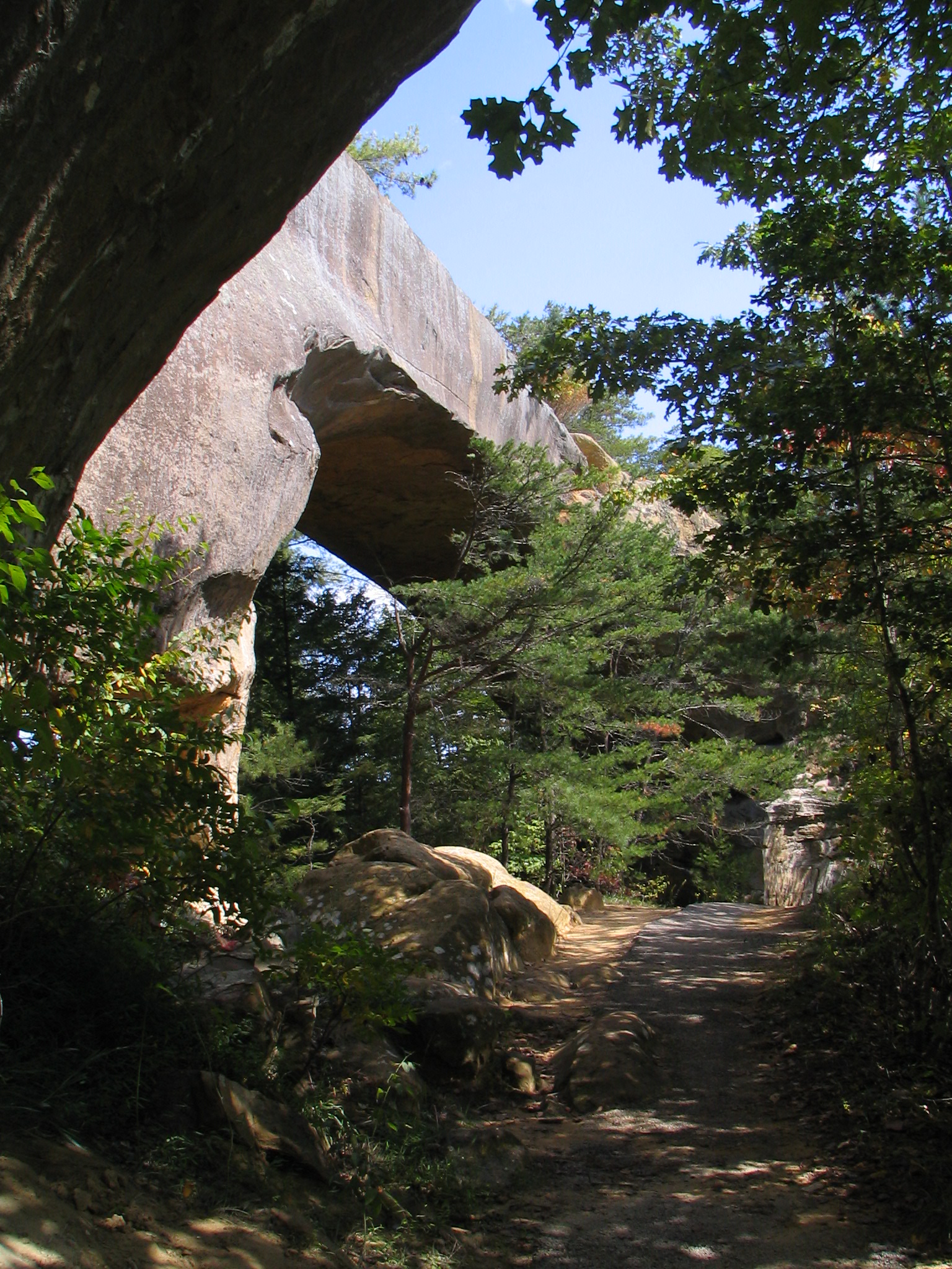
Auxier Ridge (#204), Auxier Branch (#203), Double Arch (#201) Loop – If you are feeling adventurous you can hike out to the end of the Auxier Ridge trail and follow the Auxier Branch trail to the Double Arch trail. If you turn left at this trail junction you will complete about a 5 mile loop without ever seeing Double Arch. However, turning right takes you to Double Arch trail which is a 1.5 mile (round trip) out-and-back from the Auxier Branch/Double Arch trail junction. The view from Double Arch is specatcular, and definitely worth the extra hike. Including the out-and-back to Double Arch the total distance is about 6.5 miles. One nice thing about this hike is that the last mile or so is along an old road (part of Tunnel Ridge Road that is no longer used for vehicular traffic, except by the Forest Service for maintenance and emergencies) back to the trailhead; so, when you are at your most tired the hike becomes much less strenuous.

Double Arch
Double Arch (from below)

View through Double Arch across the valley to Auxier Ridge
Gray’s Arch (#205), Rough (#221), Pinch ‘Em Tight (#223) Loop – The Gray’s Arch trailhead and parking area are located on Tunnel Ridge Road approximately 0.75 miles after you turn off of KY-15. This is a fairly rugged hike, about 6.5 miles in length, including an unofficial side trail out to a very scenic spot. This side trail (~0.25 miles one way) is not an official trail, so it is not marked with any signage. It is pretty well used, though, so it is fairly easy to find, and branches off to the left just past the junction of Rough Trail (#221) and Rush Ridge Trail (#227), assuming you are traveling the loop in a clockwise direction. The side trail is well worth the added hike as it ends on a high point with a spectacular, panoramic view overlooking the valley below…a great midway point on the hike to stop for lunch!!
- Gray’s Arch & Daniel Boone Hut Trails (US Forest Service Downloadable PDF Map)
- Rough Trail #221 (US Forest Service Downloadable PDF Map)
- Tunnel Ridge Road Reacreation Area (US Forest Service Downloadable PDF Map)

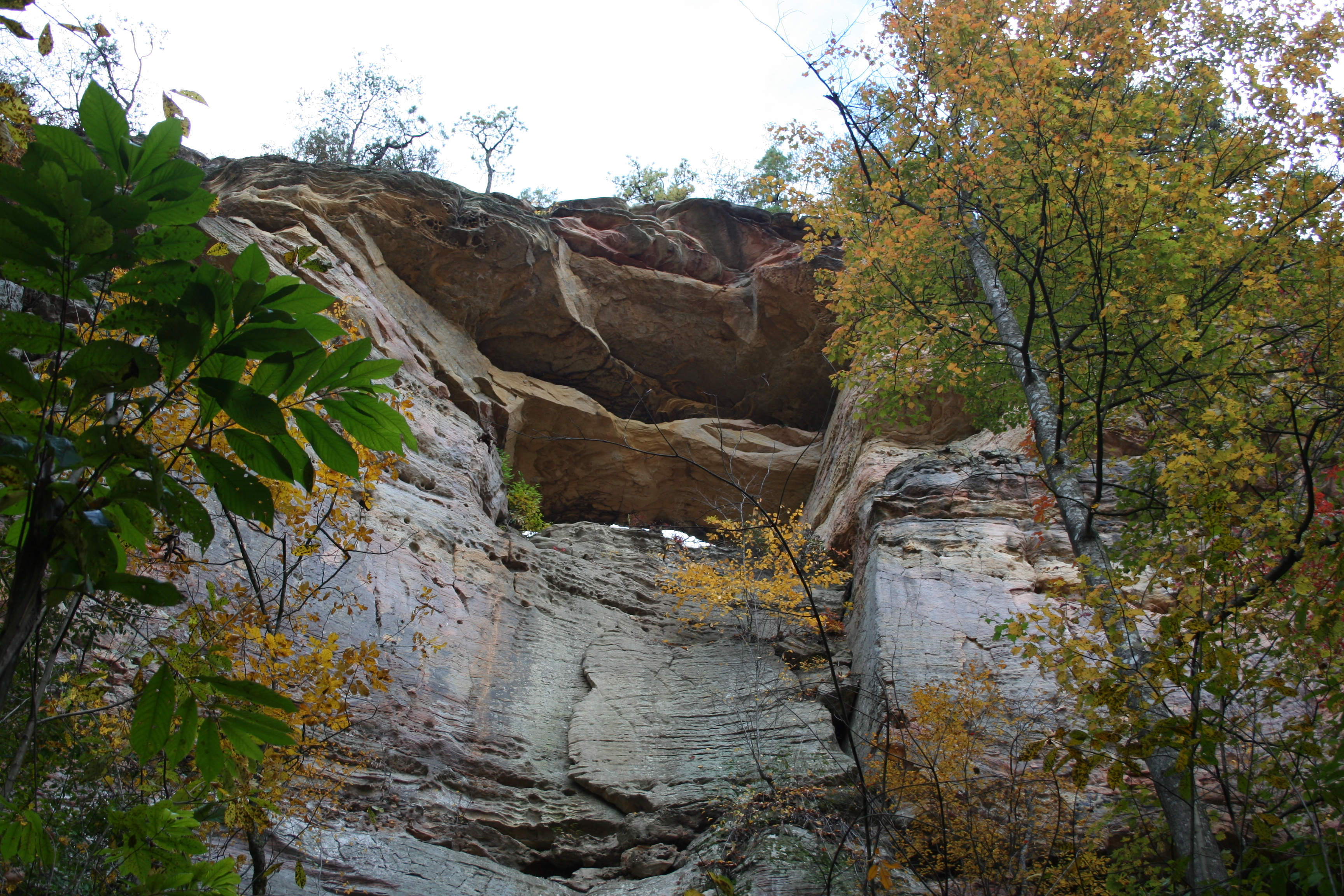
Gray’s Arch

Scenic view at the end of an unmarked trail off of Rough Trail
___________________________________________________________________
RESOURCES
Camping/Lodging:
- Koomer Ridge (US Forest Service) – Camping
- Natural Bridge State Resort Park (Kentucky State Parks) – Camping and Lodge
- Red River Outdoors – Cabins (see photo)

The Whip-Poor-Will cabin at Red River Outdoors
Internet Information:
- Daniel Boone National Forest (US Forest Service website)
- Red River Gorge Geologic Area (US Forest Service website)
- Natural Bridge State Resort Park (Kentucky State Parks website)
Information and Exhibits:
Gladie Visitor Center
3451 Sky Bridge Road
Stanton, KY 40380
(606) 663-8100 during operating hours [(606) 784-6428 when closed]
Located on the north side of the gorge area on KY-715, the Gladie Visitor Center has nice interpretive exhibits and is a good place to get information on trail conditions, closures, etc. They also have more detailed maps and trail guides available (some free, some for purchase) as well as recreation fee passes which are required if you plan to be parked between the hours of 10 PM and 6 AM do any overnight, backcountry camping (a pass is not required for front-country camping in the Koomer Ridge Campground). Fee passes are NOT required for day hiking in Red River Gorge.
Note: Typical hours/days of operation from early spring through late fall are 9:00 AM to 5:00 PM Friday through Monday, CLOSED Tuesday through Thursday. The Gladie Visitor Center is closed from late fall through early spring.
Natural Bridge State Resort Park
2135 Natural Bridge Road
Slade, KY 40376
(606) 663-2214
Located on the west side of KY-11 about 2 miles south of the Bert T. Combs Mountain Parkway, Natural Bridge State Resort Park has both a gift shop, where you can get information and maps, and a nature center that has nice exhibits relating to the natural and human history of the area.
Books:
Hiking Kentucky’s Red River Gorge by Sean Patrick Hill, published by Menasha Ridge Press, Birmingham, AL, 2012.
This is a current, complete, and well researched (the author has personally hiked every trail he writes about) guide to the official trails in the Red River Gorge area. This book is the best one I have seen on the Gorge in terms of both content and format. The trails are presented as complete, self-contained hikes, which gives you to ability to choose your destination based on scenic attractions, distance, and difficulty level. If you plan are planning a trip to Red River Gorge, I highly recommend this book!
Hinterlands 2020 by Jerrell Goodpaster, published by Lost Branch Productions, Owingsville, KY, 2020.
This is the updated version (I have the one published in 2008) and a gem of a book for experienced hikers wanting to explore the “Hinterlands” of Red River Gorge! The author has spent many years exploring the area, and has compiled a comprehensive volume of over 100 unofficial trails. For each trail he includes a summary of distance, highlights, and cautions, followed by detailed directions to the trailhead and descriptions of what you can expect to find along the trail (with painstakingly measured distances), elevation profile charts, and GPS coordinates for major points-of-interest. He also rates each trail, on a scale of 1-10, for its aesthetic quality and difficulty. Having hiked in the area, and knowing the terrain, I would strongly recommend that you heed the author’s warning that this book is a “down-n-dirty guide for experienced hikers, rather than another general guidebook for casual hikers or walkers.”
Note: the author wrote an earlier book on the official trails, Red River Gorge Trail Guide, also published by Lost Branch Productions. I have not read this book so I cannot comment with authority, but judging from the quality and thoroughness of Hinterlands I would assume it is an excellent guide.
Kentucky’s Land of the Arches by Robert H. Ruchhoft, published by The Pucelle Press, Cincinnati, OH. 1986.
This book is dated but still very complete, including detailed sections on the history and geology of the area, which are quite an interesting read. I do find the format of the trail guide sections a bit cumbersome and difficult to follow, though the descriptions do contain a lot of detailed information and cover all of the trails in the area. There are black & white topographic maps included for major areas of the Gorge, but they are difficult to read with no shading or color.
Out of Print – Hiking the Red by Bluegrass Group Sierra Club, published by Harmony House, Louisville, KY, 2000.
This book gives a nice overview of the area along with simple maps and concise descriptions of most official trails in the Red River Gorge area. It is well done and useful to get an overview of what to expect on any given trail. That said, the book is currently out of print and not worth the asking price on Amazon.com, especially with the more recent publication of Hill’s outstanding book.
Maps:
Red River Gorge Backpacking Guide (9th Edition, 2022), outrageGIS Mapping:
Description from the outrageGIS.com website:
- GPS mapped trails and backcountry campsites
- 1:15,840 scale map set — significantly more detailed than any other map!
- A gorgeous full-color map that shows forest canopy cover
- 50-foot elevation contours & GPS coordinate grids
- Bird’s Eye View map and trail elevation profiles
- Sunrise and sunset locator map to find the best campsites
- Map showing local eateries and tap-rooms
- Lamination available
If you are planning to do any amount of hiking in the Red River Gorge area I highly recommend this set of maps which includes most of the gorge area trails plus a substantial amount of detail not shown on other maps. You can purchase this set of maps online from outrageGIS Mapping or from various vendors in the area. We purchased our set (an earlier edition) several years ago at the Gladie Learning Center for about $15 and have found them extremely useful for all of our explorations in Red River Gorge. According to a reader’s comment (thanks John!) the map set is no longer available at the Gladie center, so you will need to check one of the stores in Slade, or you can always order them online at the link above.
- Slade Quadrangle, Kentucky, 7.5-Minute Series
- Pomeroyton Quadrangle, Kentucky, 7.5-Minute Series
- Frenchburg Quadrangle, Kentucky, 7.5 Minutes Series
(1.21 MB) – This map gives you a good overview of the area showing locations of all the roads, trails, and scenic attractions (does not include details of Natural Bridge State Resort Park). This map is not intended for navigation purposes, though it will suffice on some of the shorter (<1mile), well-marked/travelled trails.
US Forest Service Daniel Boone National Forest Day Hiking Areas:
This web page has links to a multitude of downloadable PDF trail guides and maps throughout the Daniel Boone National Forest. Scroll through to the Cumberland Ranger District, Red River Gorge Geological Area to find all of the maps/guides for the Red River Gorge area trails.
Natural Bridge State Resort Park Facility and Trail Map
© Todd D. Nystrom and Todd the Hiker, 2013-2022.

So our trip do do a loop starting at greys arch trailhead was planned for this weekend. I just called in and the whole forest is on a fire ban so if we did still go backpacking we could only use our stoves and no open fires. Any suggestions on an audible here? I saw we could camp at koomer ridge and then day bike from there (they have the metal fire rings so we could have an open fire) but we still wanted to backpack. Any way around this or any trails that would have fire rings?
Justin,
There really is not another option to be able to have a campfire with the current ban in effect. Technically there are no official backcountry campsites so all the campsites shown on the OutrageGIS maps just have rock fire rings built by previous backpackers, and not the required, official, metal fire rings. The only metal fire rings are those in the frontcountry campgrounds at Koomer Ridge (USFS) and Natural Bridge (KY State Parks).
The only possibility I can think of that would still involve backpacking is to plan your route to include the Koomer Ridge campground which is not too far off the loop you were already planning. That said, those campsites fill up quickly in the fall, and you would risk of not being able to find an open one, in which case you would have to resort to camping in the backcountry without a campfire.
I wish I had other options to suggest. I know there is some rain coming through tonight, but I doubt it will be enough to get them to lift the ban. Either way, I hope you can somehow salvage your trip.
Todd
Justin,
I have some great news for you!! About 30 minutes after posting my previous reply I saw a post come across my Facebook feed from the Daniel Boone National Forest saying they have lifted the fire ban. Full details can be seen here: https://www.fs.usda.gov/detailfull/dbnf/alerts-notices/?cid=fseprd673168&width=full.
Enjoy your trip and the time around the campfire!!
Todd
Thanks Todd!
Todd,
My dad and my 2 brothers are looking to do a trip this fall (end of October) for 2 nights backpacking. We have never been to this park but have heard great things. We all love the outdoors but have limited experience with backpacking. We are all in decent shape and I wanted to know what trails you would recommend. We are planning on driving down from Indianapolis Friday night and camp somewhere close to where we parked our car, then get up and hike Saturday (5-8 miles) to a campsite and then hike back Sunday. Would love recommendations for this trip.
Thanks,
Justin
Justin,
I will start with the recommendation I make to anyone planning their first backpacking trip to RRG, which is to get the OutrageGIS, “Red River Gorge Backpacking Map.” This map is in its 8th edition and is the best available map of the area, hands-down. It is especially helpful for finding the best spots to camp which, without knowing the area well, can often be challenging.
My second recommendation is to get there earlier on Friday, if possible. Fall is generally the busiest season in the gorge and trailhead parking fills up fast on nice weekends. Also, keep in mind you must be 300 feet away from roads and official trails to camp, and the spots meeting those requirements, that are also close to the trailhead tend to get taken quickly. The gorge is not a place you want to be walking around in the dark trying to find a place to set up camp.
As for trail recommendations, I will suggest the loop formed by the combination of the Grays Arch (#205), Rough (#221), Koomer Ridge (#220), Buck (#226), and Pinch-em Tight (#223) trails. With the Rush Ridge (#227) trail included, this series of trails creates three interconnected loops ranging from 3.5 miles up to about 11 miles, which allows you to tailor the distance as desired. This area can be accessed directly by parking at the Grays Arch or Pinch-em Tight trailheads on Tunnel Ridge Road. As an alternative, I often suggest the Auxier Ridge/Double Arch and the unofficial trails in that area, as the views are arguably the best in the gorge, but in the fall, those spectacular views also mean big crowds and difficulty finding an unoccupied spot to camp unless you know the area well.
Hopefully this helps with your planning. Let me know if you have any other questions; and enjoy your trip to the gorge!!
Todd
That was a lot of help thanks! Got the map and I love it. Next question is how can I purchase the backcountry parking pass? We can’t get to the park until late (after 9) Thursday night and I believe you can only purchase it locally and I am assuming all places would be closed. Can I get it online?
Justin,
You are welcome!
I have always bought passes at the Shell station (phone: 606-663-4100) in Slade, KY (exit #33) where you get off the Bert Combs Mountain Parkway to go to RRG. According to the Daniel Boone National Forest page listing locations to buy a permit (URL: https://www.fs.usda.gov/detail/dbnf/passes-permits/?cid=stelprdb5332558 ) that Shell station is open until 11 PM. Also, in the listing is a Shell station (phone: 606-663-5000) in Stanton, KY that is open 24×7 that also sells permits. You pass Stanton about 10 miles before the Slade/RRG exit. In either case it is best to call and make sure those hours are current.
Todd
Todd,
What a great article. And THANK YOU for the mention of OutrageGIS mapping and link! I just submitted an order for their RRG trail map.
I have been down to RRG for a couple of day hikes a few years ago. I am an experienced backpacker, hiking long distance and multiple nights on the trail however my friend that will be going down with me, not so much. I am getting him out on trails now to try and build up some experience and stamina. We are going to go down Labor Day weekend to do a 3 days/2 nights of backpacking. I’d like to do some easy to moderate hikes where I’m not driving from one trailhead to another. I want us to start at a trailhead, hike to a campsite, hike the next day to another campsite then hike back to our original trailhead. Do you have any recommendations/suggestions? I am thinking that a 6-8 mile daily average would probably be ok for my friend. I’d appreciate any input you could give.
Thank you and God bless!
Kevin Nicholas, servant of the Lord Most High
Lebanon, OH
Kevin,
Thank you! Having the OutrageGIS map is key for detailed planning and finding the best campsites and hidden views.
As for a recommendation, the largest loop in the gorge that does not require hiking on any roads, is a combination of the Grays Arch (#205), Rough (#221), Koomer Ridge (#220), Buck (#226), and Pinch-em Tight (#223) trails, which is in the 11 mile range. This loop can be accessed directly by parking at the Grays Arch or Pinch-em Tight trailheads on Tunnel Ridge Road. You will pick up a few extra miles if you explore some of the unofficial trails off of this loop (recommended) that you will find on the OutrageGIS map. Also, you will find the best campsites, some of which come with spectacular views, out on these unofficial trails.
If you want to extend your mileage, there are a few alternative trailheads and approaches to this loop you can consider, as follow:
1) Martins Fork trailhead on KY-77, approaching the loop from the west on Rough Trail (#221). This is a small parking lot that fills up fast because it is a prime spot for several of the big climbing walls.
2) Sheltowee Connector Trailhead on KY-715, approaching the loop from the north on the Sheltowee Connector (#211) and Sheltowee Trace (#100) trails. This route has the bonus of crossing the suspension footbridge over the Red River on the Sheltowee Trace trail and some great views of Chimney Top Rock from down below.
3) Rough Trail trailheads on Chimney Top Road (shorter) or KY-715 (longer) approaching the loop from the east on Rough Trail (#221). Starting at the KY-715 trailhead gives you the longest route, but also adds several sizable vertical descents and ascents and is probably the most challenging of the options.
4) Koomer Ridge traihead on KY-15 at the Koomer Ridge campground approaching the loop from the south on the Koomer Ridge Trail (#220).
All these alternatives add several miles to the route, but you will be repeating the approach sections of trail to access the loop.
One other option is to hike the Auxier Ridge (#204), Auxier Branch (#203), and Double Arch (#201) loop which is much shorter (only about 6.5 miles), but if you include the out-and-backs on the two unofficial trails, Star Gap Arch and Jailhouse Rock, off of this route you will be up in the 15 mile range. The views on this route are probably the best in the gorge and, because of this the official trails will likely be busy, but, once you get out on the unofficial trials, the crowds will disperse and you should find some solitude.
There are other loops you can create but they all involve hiking sections of road, which I generally would not recommend on a busy holiday weekend unless you work your plan to hike the road portions early in the morning before the vehicle traffic gets too heavy.
Hopefully this is helpful! Feel free to reach out if you have any questions.
Safe hiking and God Bless!
Todd
Hi Todd, thank you for your blog. My husband and I live in Cincinnati as well, and are going for a weekend get-away on the 16th and 17th of this month. I have been scouring the internet trying to find the best hikes and found your blog, it is excellent. We are all about taking in God’s creation! We’ve had the privilege of hiking into the remote, very rugged, areas of Tariquia, Bolivia twice now on mission trips. What do you recommend for a longer, very scenic hike for our Saturday? I figure on Sunday we can take in the shorter hikes you mention, to see some of the easier accessible sites, unless you have a better suggestion. Thank you again, blessings!
Kimberly,
Thank you!
My usual recommendation for a first time visit to Red River Gorge is the Auxier Ridge, Auxier Branch, Double Arch loop which is normally about a 6.5 mile hike with what I consider the best views in the gorge. However, with Tunnel Ridge Road currently closed beyond the Gray’s Arch trailhead you would have to park at the Gray’s Arch trailhead and hike the closed portion of Tunnel Ridge Road (about 3 miles one way) to get to the Auxier Ridge trailhead making the total distance around 12.5 miles.
Alternatively, I recommend the Gray’s Arch, Rough, Pinch ‘Em Tight trails to form a 6.5 mile loop, which could also be extended by including the Koomer Ridge and Buck trails to create a loop of about 10 miles. There aren’t as many sweeping panoramic views on these two routes, but you will at least be hiking on trails the entire way rather than having to hike half the time on the road.
Either way, you really can’t go wrong as the scenery is beautiful no matter what.
Have a great time down in the gorge taking in some of God’s amazing handiwork!!
Happy Trails,
Todd
Thank you so much for the suggestions. We are very much looking forward to it.
Kimberly,
I just saw an update today from Daniel Boone National Forest that they have reopened Tunnel Ridge and Rock Bridge roads. You will now be able to get to the Auxier Ridge trailhead to hike the Auxier Ridge, Auxier Branch, Double Arch loop, which is the hike I most recommend for your first trip to RRG.
Enjoy your trip and the amazing little corner of God’s creation down in the gorge!
Todd
Todd,
What great news! Thank you so much for giving me the update.
Blessings,
Kim
Hi its elisha again. We r leaving for are backpacking trip for the gorge on thurs. I was wondering, where is a good place to park are car and start from. We have dogs so, I know there is areas they can’t go. Thanks for all u do.
Elisha,
The only place dogs are not allowed is in Natural Bridge State Resort Park; leashed dogs are allowed in all the National Forest areas including Red River Gorge and Clifty Wilderness.
Since you are going on a Thursday you should have no problems finding parking even with the road closures. I would recommend the Gray’s Arch trailhead for parking and as a great starting point as it gives you easy access to the central loops of the Gray’s Arch, Rough, Pinch ’em Tight, Buck, and Koomer Ridge trail system. Alternatively by parking at the Gray’s Arch trailhead you could also hike down Tunnel Ridge Road (which is currently closed to vehicle traffic beyond the Gray’s Arch trailhead) to get to the Auxier Ridge, Auxier Branch, Double Arch loop which will probably be pretty empty given the closure of Tunnel Ridge Road.
Enjoy the gorge, stay safe, stay warm, and happy trails!!
Todd
Thanks Todd! You have been so helpful. I wish I could find someone like you for every park we go to. You doing this for other hiker is just awesome. Thanks again.
Todd, first of all… great articles and insight! Thanks for taking the time to share! We’ll be headed down to the RRG (first trip) on Wed Mar 6… backpacking Thu Mar 7-Sun Mar 10. We’re three experienced backpackers (plus one first-timer) – but we’re unfamiliar with the RRG. We’ve already had to change our route plans a few times bc of road closures, etc.
My biggest question at this point is in regards to the water crossings. What can we expect (especially with recent and expected rain/snow)? Might they be ankle deep? Knee deep? Waist deep? Any rock jumping or log hugging? I know it’s impossible to say without being there yourself… but just trying to gauge if some of them might not be passable at all.
Our route plan is below… so, we’ll be crossing Right Fork/Chimney Top Creek (several times) and Rush Branch… maybe a few others along the way. Just kind of curious what your experience or knowledge of them is.
ROUTE PLAN: Koomer Ridge > Buck Trail > Pinch Em Tight > Rush Ridge > Rough Trail > Sheltowee > Bison Way
Thanks in advance for your help and thank you again for info you’ve already provided!
Ryan,
Thank you and I am happy to hear my pages have been helpful!
We have hiked all the trails you mention and have never had a problem with any of those Creek crossings, but we have not been there after a period with as much precipitation as we have recently seen. Under normal conditions you are fording at a shallow spot with water not much higher than ankle deep, or you can pick your way across by stepping from rock to rock.
However, with all the recent rain, it is possible you could encounter a crossing with knee deep water and you will definitely have to navigate through some extended muddy areas, especially on the Sheltowee Trace along Chimney Top Creek (there is a photo of one of the “normal condition” crossings of Chimney Top Creek in my “How to Not Get Lost on the Trail” blog post). This section of trail follows the flat creek bottom for a good distance and has a several crossings; and, being one of the wider creeks, it could be a challenge to cross if they get any heavy rains in the days leading up to your trip.
As with any trip, keep an eye on the weather and consider how you might alter your route on the fly if any of those crossings turn out to be risky. Being experienced backpackers and having thought through your route already, I suspect you will be fine, though.
Happy trails,
Todd
Thank you, Todd! This is EXACTLY what I needed to know. Knowing that the creeks are typically ankle deep gives me some perspective on what to expect. The extended forecast continues to change daily… so, we’ll keep a close eye on things and make necessary adjustments. I’m ok with some mud and even rain showers… it comes with the territory… but I just want to make sure we’re being cautious in regards to the water crossings. Thank you again for everything you’ve prepared and for taking the time to respond! I’ll share a brief trip report when we get back and let you know how we fared.
Ryan,
You are welcome! I look forward to hearing what you encounter as I hope to get down there for a short trip later in the month.
Happy trails,
Todd
I am a hiker for years. But never backpacked. Planning 4 day backpacking trip to the red river Gorge. What trails do u recommend that there is water so we don’t have to carry water weight. Where to start and where to end? And the best spots for water? Thank you for your time and help truly appreciate all you do for hikers
Thank you
Elisha Hower
Elishahower@gmail.com
Elisha,
You don’t indicate a time-frame for your trip, but be aware that the gravel roads in RRG—Chimney Top Rock Road, Rock Bridge Road, and Tunnel Ridge Road (beyond the Gray’s Arch trailhead)—are currently closed due to all the recent rainfall and likely won’t be open for a couple of months. That said, no matter when you go I recommend checking the Daniel Boone NF “Alerts & Notices” page and the Daniel Boone NF Facebook page for updated closure information before you go.
As for availability of water, unless there is an extended dry period, basically any route that takes you down off the ridges into a valley will have a creek where you can collect water which will need to be filtered, treated, or boiled. As I remind everyone, there are no sources of potable water in RRG, even at the trailheads, so don’t expect to be able to fill water bottles at the start of your hike.
An additional water related consideration, especially if you are planning your trip in the near future, many trails will be muddy and slippery, and some creeks may be high and difficult to cross after heavy or extended periods of rainfall, so be prepared to get wet and possibly adapt your route on the fly if you encounter impassable trail conditions.
I will suggest a couple of general areas to consider; however, you will need to do some detailed planning based on the distances you want to hike each day and whether you want to start and end at the same trailhead or use two vehicles to shuttle between your start and end points.
One good area to explore is the trail system including the Rough, Gray’s Arch, Rush Ridge, Pinch-em Tight, Buck, and Koomer Ridge trails. There are several options here that involve interconnected loops that would allow you to start and finish your trip at the same trailhead or just weave your way around to start and end your hike at a different trailhead. Even with the road closures mentioned above, you can access this area from any of the following trailheads:
– Martins Fork trailhead on KY-77 at the west end of Rough Trail
– Rough Trail/Swift Camp Creek trailhead on KY-715 at the east end of Rough Trail
– Koomer Ridge/Hidden Arch trailhead off of KY-15 at the Koomer Ridge campground
– Grays Arch or Rough Trail trailheads, both on Tunnel Ridge Road off of KY-15
– Sheltowee Connector trailhead off of KY-715 by hiking south on the Sheltowee Trace to connect with this system
Another possibility as long as Tunnel Ridge Road remains closed is to park at the Gray’s Arch trailhead and hike on Tunnel Ridge Road to access the Auxier Ridge, Auxier Branch, Double Arch trail system. That trail system would normally be too short for a 4 day trip, but with the need to hike down and back Tunnel Ridge Road due to the closure it could be a good fit for the schedule and might be an interesting option with less people, as well.
I will also make my standard suggestion to get the OutrageGIS Red River Gorge Backpacking Map as it will help you find the established campsites as well as some of the hidden scenic spots that won’t be shown on the official maps. The USFS topographic map of RRG is also useful to have, but it only shows the official trails and has no information on campsites since there are actually no official campsites in the gorge.
Let me know if you have any other questions, and enjoy your trip to RRG!!
Todd
Thank you so much Todd. You have given me so much information, stuff u can’t find anywhere else. We r leaving sometime in March. Hopefully the roads will be open by then. I’m sure I will have more questions as time gets closer. Thank you again so much.
Elisha
Elisha,
You are quite welcome. I think there is a good chance the roads will be closed through March, but even if they are, all the recommendations I made work even if that is the case.
Enjoy, and feel free to reach out if you have more questions!
Todd
Todd, I am wanting to plan a overnight (one night) backcountry hike. Any recommendations on what trails/routes might be good for this trip? I’m in pretty good shape but this will be my first overnight (backcountry) hike. Any recommendations you can give would be appreciated. Thank you.
Joe,
I would recommend either one of the trails mentioned on my Red River Gorge – Off Trail page These are both well-traveled, unofficial trails with several great established campsites and a lot of incredible views. If you are feeling especially energetic and would like to add some distance (appx. 6 more miles) to your hike you could combine either one of those trails with the Auxier Ridge, Auxier Branch, Double Arch loop…also with incredible views. Keep in mind there is no easy access to water on either of those unofficial trails as both are along the top of ridges. Also, there is no water at the trailhead so make sure you pack along whatever you need for the day, night, and next morning until you get back to the trailhead.
Enjoy your first backcountry overnighter, and Red River Gorge!!
Todd
How would we find hike able trails throughout the red river gorge cabin rentals next to Sussanas arch trail?
Sophie,
From what I know Suzanna’s Arch is on private property in the Cliffview resort area, but I don’t know anything about the trails there. Perhaps there will be information provided in the cabin you are renting, or through the person or company from whom you rented the cabin.
While I cannot help with information on trails in that area, I would be happy to answer any questions you might have about the trails in the Red River Gorge Geological Area of Daniel Boone National Forest.
Todd
Thank you so much for the excellent and detailed information! We just returned from our first trip to Red River Gorge with our 3 children. I used your post and a trail map to find appropriate hikes and we were able to hike 6 different trails in 2 days. We thoroughly enjoyed our time in beautiful RRG.
Lindsey,
You are quite welcome. I am happy to hear the information here was helpful, and also that you and your family enjoyed RRG so much!
Happy trails,
Todd
Hi Todd. My husband, our 11 year old and myself are beginning our backpacking adventures. We live about 2 hours north of Cincinnati. We are planning a 4 day 3 night trip to the Washington Olympic National Forest in late July early August. Before doing so we have a few weekend trips set aside to get ready for this. I was recommended the RRG, and stumbled upon your website. We are hoping to get a 1-2 night trip out of this. I see that the tunnel bridge road is still closed as of today. We are all very active and have hiked numerous times, but have never backpacked/overnight backpacked. I see in the previous comments two different loop hikes that you recommended. With the tunnel bridge road being closed, is that the only entry access to that loop? If you could email me with any help, it would be much appreciated! Thank you!
Lindsay,
I will send you an email with more info.
Todd
Hello! Thank you for posting all of the helpful information! My husband and I are really looking forward to our trip. We were hoping to do some backcountry camping, preferably off the Auxier Ridge Trail as you recommend. I also have concerns about the road closure and accessing these trails. Would you be able to email me this information as well? Thanks!
Sent!
FYI, we just spent the week Hiking around Turtleback arch….the trails are trashed by fallen trees and impassable in many areas, requiring cutting thru lots of thorny thickets, you cant really complete the trails end to end past Tophu rock, etc. The rangers really need to get out and clear the trails they are in sad shape.
Thanks for the info. I know I have encountered some difficult sections on the Swift Camp Creek trail (particularly washouts and downed trees) in the past. Hopefully other areas/trails are not impacted as significantly.
Headed to the Gorge this weekend. We plan on heading out Saturday around 4, when we arrive and staying out until Monday morning. We need to be back at our car by 8am. Are there enough trails to keep us busy if we take the Rough Trail out and maybe do Chimney Top and then loop back on Pitchem Tight? Then if we still have time I was thinking we could head out into Auxier. The other option was to take the Rough Trail out to Sheltowee Suspension Bridge, walk along the road and then head out and do the big loop Sheltowee Trace ending at Copperas Creek Trail Head…thoughts?
Mary,
One of the first things to be aware of is that you will not be able to drive in to access any of the trailheads along Tunnel Ridge Road as it is still closed for construction, this includes the Pinch-em Tight, Gray’s Arch, and Auxier Ridge trailheads.
I am not sure how many miles you plan to hike each day, but hiking Rough Trail from the Martin’s Fork trailhead (on KY-77) to the Rough Trail trailhead on Chimney Top Road is a little over 6.5 miles and returning via Pinch-em Tight is around 5.25 miles. You could also return via the Koomer Ridge and Pinch-em Tight trails which is around 6 miles. I think there are plenty of trails to keep you busy in this area, especially since Rough Trail has quite a few ups and downs and definitely lives up to its name.
The other route you mention, hiking Rough Trail to the Sheltowee Trace suspension bridge and around the big loop to the trailhead at Copperas Creek is quite a bit longer, and also will have a couple of creek crossings that could be pretty challenging with all the rain this week.
All this said, I always like to add cautionary notes, especially when I don’t know how much experience someone might have hiking in the Gorge. It is pretty rugged and there will likely be some muddy areas with all the recent rain, so it could be slow hiking at times. Also, make sure you have good maps, as there are quite a few intersecting trails in the areas you mention, and it is easy to take a wrong turn. On one of our day hiking trips down there last year we had to give someone a ride back to their car because they missed a turn and ended up several miles off course.
Cautionary notes stated, stay safe and enjoy your time in the Gorge!
~Todd the Hiker
Thank you so much! I am really excited. I guess we will have to save Auxier Ridge for another trip. We will stay around the Rough Trail and just relax and explore that entire area.
You are welcome! Enjoy the Gorge!
Hello Todd,
Glad I stumbled upon your site. I happen to be from Cincinnati, as well, and I attend New City Presbyterian Church (PCA) in Norwood. I am rather new to hiking and have scheduled a couple of days away during my spring break at a cabin near RRG. It is close to Rock Bridge/Creation Falls, Chimney Top, and Sky Bridge. My only real hiking experience was at Zion National Park several years back, but I enjoyed it and am hoping to get more into hiking/camping, etc. I have about 3 days to explore what I can, but for my first time, I don’t want to do anything too crazy (nothing unmarked or more than a few miles total in one hike.) I’m in good shape physically with strong legs, so for that I am grateful! Thanks again for posting a helpful site. -Sara
Sara,
Thanks for stopping by and you are welcome! New City is a wonderful church and Josh is a wonderful pastor! Being in good shape, you should have no problems with any of the trails. Just make sure you are prepared for mud with all the recent snow and rain they have had down there. One limitation to be aware of is that Tunnel Ridge Road is still closed to vehicle traffic (as of March 27th) due to construction so you won’t be able to access any of the trailheads along that road; but, you really can’t go wrong with any of the trails down there. Enjoy your time away and the amazing little corner of God’s creation that is Red River Gorge! ~Todd the Hiker
I am looking for a overnight hike (1-2 nights) about 8-10 Miles each day that would be good with a 9 and 11 year old. Any suggestions??
Jason,
Based on your question, I assume the 9 and 11-year old have some experience on longer, more difficult hikes; but, even so, I will qualify my recommendations (especially where children are concerned) by re-emphasizing the challenges and dangers of Red River Gorge with its rugged, steep climbs and descents, as well as the sudden drop offs and high cliffs. A lot of people underestimate the ruggedness and difficulty of navigating the trails in RRG, so also make sure you carry a good map; and, as usual, I will recommend the OutrageGIS maps as they show the official and unofficial trails along with the good campsites and best views. These qualification out of the way, I have two recommendations, either of which make a good one to two-night trip.
The first route is the loop (appx. 6.5 miles) formed by the Auxier Ridge (#204), Auxier Branch (#203), and Double Arch (#201) trails, which I briefly describe on this page, coupled with the two unofficial trails mentioned on my “Red River Gorge – Off-Trail” page. The out-and-back distance for the two unofficial trails is about 4 miles each, which brings the total hiking distance to around 14.5 miles. This route includes some of the most spectacular views in RRG, and is one I highly recommend to everyone. Also, there are several great camping spots on these two unofficial trials. One thing to be aware of with this route is that Auxier Ridge trailhead is only accessible via Tunnel Ridge Road, which has been closed for construction since late last year. It was supposed to re-open in early March, but that has been delayed by the weather, so you should check the “Alerts & Notices” on the Daniel Boone National Forest website before you go.
The second route is the loop (appx. 10.5 miles) formed by the Gray’s Arch (#205), Rough (#221), Koomer Ridge (#220), Buck (#226), and Pinch-em-Tight (#223) trails. This route has a lot of significant ascents and descents and is more difficult than the other route, even though it is a shorter distance. There are also not as many spectacular views on this route, but the scenery is still great in my estimation. An advantage of this route is that it can be accessed from several different trailheads including Martin’s Fork (on KY-77), Rough Trail (on Chimney Top Road), Koomer Ridge (on KY-15), and Gray’s Arch (on Tunnel Ridge Road), with only the Gray’s Arch trailhead being affected by the previously mentioned road closure.
I hope these recommendations help and enjoy the Gorge!
Todd the Hiker
Thanks for your help
Auxier Ridge is excellent! I took my teens on it a few years ago. It has enough danger to excite a new backpacker but nothing really crazy. Basically, the first day is a hike across a “knife blade” of a trail. Hundreds of feet of cliff on both sides of the trail with awesome views. I had the talk with them about the dangers of not paying attention before we set out and I found within the first hour they learned to respect the seriousness of how easy it would be to trip and fall off the edge. After that they were wide-eyed and had a GREAT time! Take binoculars and plan a lot of stopping and looking time!
I always double my estimate of hiking time whenever I take someone on this route for the first time! It is certainly one of the hikes that got us hooked on RRG!
Hey Todd,
I’ve backpacked in the Gorge quite a bit and I was wondering if you knew of a way of getting to the Swift Camp Creek trail from the Osborne bend trail without going town 715. I have found some inklings of a Calaboose Ridge trail that goes near the cemetery in the Clifty Wilderness. Do you know of any way up to there from the Copperas Creek Canoe Launch? We were planning on a 3-4 day hike from Corner Ridge to the the Rock Bridge.
Thanks,
Karl
Karl,
Unless Swift Camp Creek is low enough to follow the creek bed, which would also probably involve some bushwhacking, I don’t know of any unofficial trails that connect from the canoe launch area to the official Swift Camp Creek trail. I know there is an unofficial trail that starts about 3/4 mile down 715 from the bridge by the canoe launch and follows Swift Camp Creek for 1/2-3/4 of a mile, but that trail ends at least 3/4 of a mile downstream from the point the official Swift Camp Creek trail cuts west away from the creek going towards the trailhead on 715 at Angel’s Windows. I guess that’s a long way of saying, no, but that’s all I’m aware of.
Todd
Hi Todd,
We’re planning a 2.5 day backpacking trip in RRG next weekend and your website has already been a fantastic resource! We’re thinking of doing the Koomers-Rough-Grays loop on day, then the Auxier-Double Arch loop the following day (likely driving between the two). Could you please send me the JPG you mentioned in your May 5, 2016 post for good campsite recommendations? Any other suggestions are welcome as well! We want to backcountry camp as much as possible. Thank you! -Kate
kaitmikula@gmail.com
(Also, my apologies if this posted more than once – thankfully laptop technical difficulties are limited in the wilderness!)
Outstanding resource here! My boys and I are headed back this October. Planning a Rock Bridge/SCC/Angel Windows/Wildcat/SCC/back to Rock Bridge(to make a “loop”) Any suggestions on a better plan to hike the Clifty with just one car and 4 days? The only part I’m not totally excited about is hiking down Highway 715 to Wildcat trail head from Angel Windows. I’ve heard its done pretty often but just wondered if you had any input or suggestions.
Thanks!
BJ
Psalm 46:10
BJ,
First of all, thank you!
As far as your plan, I am unaware of any options for a “loop” route in the Clifty Wilderness area that do not involve either hiking along Hwy 715 or completely retracing your steps. Even the Osborne Bend “Loop” at the northern end of Clifty requires some hiking along Hwy 715. I double checked on my OutrageGIS maps to be certain, but there are not any unofficial connector trails that provide an option, either.
The only true loop with no backtracking or road hiking I know of is in the central part of the Gorge area, which is the ~11 mile combination of the Gray’s Arch, Rough, Koomer Ridge, Buck, and Pinch-em Tight trails, but that is a bit too short for a four day trip and it is not the Clifty Wilderness.
I certainly understand the concern of hiking along the road. We have done that a few times and it is always a bit nerve racking, but still doable with caution. The only other thought I have to avoid any hiking along the road would be to plan a road free, one-way route and then contact an outfitter to arrange a shuttle from your car to your chosen start point.
Todd
Thanks again for your time and effort! When I was 14 my youth group went from Rock Bridge all around and 21 miles later ended up at Koomer Ridge Campground. I will never forget that trip! A few years back I took my oldest son down Auxier Ridge and looped back around Double Arch. It was beautiful but just not as rugged as I remember that first trip to be. I think we will stick with the original plan and pack a couple safety vests for the road section. We are heading down the first week of October… I’ll be sure to post some pictures!
Sent from my iPhone
>
You’re welcome! October is a beautiful time of year down in RRG. Enjoy!
You are off to a great start on this website. We recently went to Yosemite and used a website that listed all the areas and trails, and found it way more helpful than any of the “official” sites. This seems to be what you are looking to accomplish here as well. I’ve been on only a few trails in the RRG, but look forward to exploring more. I wonder if there is a way to add comments for specific trails? I’d love to hear feedback from people who have done the hikes. Keep up the great work!
Paul,
Thank you for your kind words and feedback! I certainly intend to keep expanding the info on RRG. And, to allow comments for specific trails I just need to create a page/subpage structure where each trail has its own page and comments section. While life in corporate America is truly a blessing when it comes to earning a living, it does limit time spent on all the fun projects I have in mind, like writing and adding to my website.
Enjoy your explorations of RRG; it definitely is one of our favorite places!
Todd
Hi Todd,
I work for a Christian Ministry in Willisburg, KY. We are a residential drug and alcohol treatment center for men. I am taking 30 clients to Red River Gorge on a weekend camping trip and am looking for a place to camp relatively close to a road. I wondered if you could recommend an enjoyable place to camp. If you are called to make suggestions or help in any way please email me.
May God Bless You!
Anthony,
I’ll be in touch via email soon.
Blessings,
Todd
Email sent.
Hi!
Some friends and I are planning a 1-2 night backpacking trip to Red River Gorge in the coming weeks. I’ve read your posts about RRG and have looked around a bit elsewhere. Some of the trails we are considering are Osborne Bend, Rock Bridge Loop – Swift Camp Creek, and the End-to-End trail.
I’m a moderately experienced hiker and will be traveling with people of varying experience levels. The least fit member of our group can usually handle about 4-5 miles per day in rugged terrain, so that’s the pace that we’re aiming for.
I’d love to hear your thoughts about what trail or trails might suit us. I’m open to suggestions as I’ve only ever been to RRG a handful of times and only for day hikes.
And thanks! 😀
I have not hiked the Osborne Bend trail myself so cannot comment much on that, though I know some who have hiked it and like it.
The End-to-End (not an official name for the trail), as I understand it is basically the Sheltowee Trace from Whittleton through to KY 715 (and beyond if you are so inclined…though going beyond 715 to the north will require you to backtrack). I’ve hiked most of that route, but will say that there are limited areas to camp along most of the route from my experience. Regardless of how far you go, this route will require multiple vehicles to shuttle or backtracking on your route.
The Rock Bridge loop is very short but following the Swift Camp Creek (SCC) trail will make for a longer route. Again, this would require a 2nd vehicle to shuttle or backtracking on your route as SCC is an out and back trail, not a loop. This is also one of the most rugged trails in the gorge, especially after you get a couple miles north of the Rock Bridge loop trail, so consider the abilities of your least experienced group member.
My recommendation would be a loop of the Gray’s Arch, Rough, Koomer Ridge, Buck, Pinch-em Tight trails. This route is actually a series of interconnected trails that allows you to make a loop of as little as ~3 miles to as much as ~11 miles so you can always make adjustments based on how much progress you make or if you decide to do only 1 day instead of 2. Another big advantage of this route is that you don’t need to worry about shuttling or backtracking. And, finally, there are a number of good unofficial side trails on this route that make finding camp sites much easier, as well.
Ultimately you can’t go wrong with any trails in RRG, but you definitely want to consider the logistics of shuttling, backtracking, etc. regardless of the route you pick. Also, make sure you have a good bail out point (or points) along your route in the event that someone’s skills aren’t up to the full trip.
Thanks for the reply! I’ll definitely take your advice onboard and discuss it with my group.
Just for my own edification, what is it that makes SCC so rugged (elevation, difficult footing, etc.)? I’ve heard many a person sing its praises, but I’ve had a hard time getting a read on it, online. Some sites, such as AllTrails, rate it as an easy hike. Others, such as the USDA official site rate it as being difficult.
Rugged terrain in places, more on the northern section of the trail. Footing can be an issue in a number of places depending on how much rain there has been (not sure how much they’ve had this summer).
Todd – The website you suggested I’ve been to several times and never noticed, “Also included are GPS coordinates, topological maps indicating the location, and the author’s suggestions for the best route to the arches.” Thanks for the suggestion. I will follow up and provide you feedback.
Hope to see you on the trail. You can recognize us by the 65# golden retriever mix that is almost always with us.
Blessings to you and your family,
Rich
Thanks, Rich. I’ll keep a lookout when were down in RRG, you never know! Blessings to you and yours, as well!
Todd,
My wife and I recently returned to KY after a hiatus and have been firmed hooked by hiking the Gorge this past year, particularly the unofficial trails. We’ve done about 10 unofficial hikes in the last couple of months. We have the outrageGIS maps, Hinterlands, membership with kentuckywilderness.com, and appreciate toredrivergorge.com, but can’t seem to find specific trail directions to so many arches and waterfalls, e.g., Cherokee Arch. The internet just doesn’t yield trail directions very willingly.
Can you direct me to web or other resources I may be missing?
In Christ’s love,
Rich & Lyn
Rich,
I would try: http://www.redrivergorgearches.com
I have not extended my explorations of Red River Gorge to that level, nor have I purchased any of the DVDs listed on the website, but based on what is shown on the sample page, this looks like a comprehensive source of the information your are looking for on the arches and, there is a link to another site listing Kentucky waterfalls.
Hopefully this is helpful. I would love to hear your feedback if this source proves to be beneficial.
Yours in Christ,
Todd
Hi Todd. My girlfriend and I are planning a trip this August to visit Daniel Boone along with other southeastern National Forests and Parks. We are planning on spending our first night at Koomer RIdge Campground and hike out first thing in the morning to backpack Koomer Ridge Trail, Buck Trail, Rough trail to Grey’s Arch, camp along that route and return the following morning. Do you have any suggestions on a good place to camp along that route? Thanks Vince.
Vince, I am sending you a Facebook message with an attached JPG file. That file is a section of the US Forest Service map of the area you are planning to backpack. On that map I have marked two unofficial side trails in blue. Both of these side trails have great views as well as good, established areas to camp.
HI Todd. I didn’t receive anything via facebook. Could you forward that to my email… vincentmarconi@msn.com
Thanks!
Done.
Hi Todd. Could you send me that jpg as well, please?
Thank you,
pjorjorian@gmail.com
Will do, Peter.
Hi Todd. I’m planning on staying at Koomer Ridge as well, and taking a break from the campsite to stay the night on one of the trail sites would be a fun addition to my trip. Would it be possible for you to send that jpeg my way too?
Thank you for all the trail knowledge on this site!
rgayheart@gmail.com
Sent.
Hey Todd, can I get u to send me that file as well. I am planning a trip now for late june. Thanks!
Certainly, Jim. I can send via email, or a direct message on Facebook or Twitter if you are on either of those. Just let me know.
mind sending again? 🙂 Headed out this weekend.
Sure, no problem, Cory. Just let me know the best way to send it.
cory at dorning dot me
Sent.
Hi Todd. Great website. My girlfriend and I are planning an August road trip to visit Daniel Boone among the other southeastern National Forests and Parks. We are planning on spending the first night at the Koomer Ridge Campground with the following day spent backpacking the Koomer Ridge Trail, Buck Trail and Rough Trails to Grey Arch, spend the night somewhere along that route and return the following day. Any good places for backcountry camping along that route? Thanks Vince
Thanks,Vince! Let me know if you received the info via Facebook or if I need to find another way to connect. Regards, Todd the Hiker.
HI, we are heading in to do a 5 day backpack trip. We like to avoid crowds and settled campsites. Is the Gorge too busy to accomplish this? If so we were contemplating the Beaver Creek & Clifty wilderness zones…..just how bad are the ticks in those areas?
Marc, if you are planning to be there during the week I would expect no crowds, even in popular areas. On the weekends the major areas around Auxier Ridge, Double Arch, Gray’s Arch, Indian Staircase, the rock climbing areas around Military Wall and Left Flank, and any of the easily accessed arches and overlooks can get pretty busy. On the weekends, though, if you get off the official trails and onto the unofficial, unmarked trails, even near the busier areas, you can avoid the crowds. As far as ticks, I cannot recall ever encountering any ticks in our many trips down there. I suspect they around, but we have been down in every month of the year and have never had any problems.
Hi Todd. Awesome website. Thanks so much for putting this together. Planning on taking my teenage kids on their first backpacking trip at the end of this month. Based on your recommendations, am thinking about trying to find a base camp somewhere not too far from the Double Arch/Auxier Ridge trailhead. I’ve order a copy of the Red River Gorge backpacking map, but was hoping you could tell me which trail and how far down the trail to get to the first decent campsite. Also, is there a stream nearby where I could pump and filter water or do we need to hike in our water? If not the Double Arch/Auxier trail, is there another trail that has some decent sites not too far from the parking area? I saw some primitive sites not too far from the Rough Trail/Gray’s Arch traihead parking areas along Tunnel Ridge Rd (39). Lastly, are there any trout streams in the area? If so where? I would like to do a little fishing while there. Any suggestions you can provide would be much appreciated. We plan on driving in from Chicago on March 31st, so hopefully finding a campsite won’t be too difficult. Thanks, Drew
Drew, thanks and you’re welcome!
On the first point, I highly recommend the Double Arch/Auxier Ridge trailhead as a starting point, especially for first time backpackers. There are two well defined, unofficial trails, Star Gap Arch and Jailhouse Rock, that start approximately 1 and 1.25 miles, respectively, down the Double Arch trail from the Auxier Ridge trailhead. The map on my Red River Gorge – Off Trail page ( https://toddthehiker.com/kentuckys-red-river-gorge/red-river-gorge-off-trail/ ) shows both of these trails, as well as a couple of unofficial campsites that we have camped in before. The location marked on the map as “Campsite 1” has more space to set up multiple tents, while the one marked “Campsite 2” is smaller, but still should accommodate a couple of tents. Both of these campsites are within the first 0.25-0.5 miles of the start of the Star Gap Arch Trail. There are other sites further out on this trail, as well. And, although I have not marked any campsites on the Jailhouse Rock Trail, there are definitely several larger sites within the first 0.5 miles from the start of that trail. This area offers you access to so many trails, official and unofficial, with spectacular scenery; it is the area I usually take first timers to RRG to get them hooked for a return trip!
There are certainly some great spots if you depart from the Rough Trail or Gray’s Arch trailheads, but those sites are a little more difficult to find and access. The scenery is equally as good, but the terrain can be a little more challenging in spots, especially for first time backpackers.
Regarding access to water, both of the trails off the Double Arch Trail run along ridge tops so there are not any streams along the route to, or near the campsites. Your best bet is to pack in the water you need, and you can always return to the car to resupply if needed. There is a stream, Auxier Branch, in the valley between Double Arch and Auxier Ridge; but, it is a pretty good hike to get to it from the campsites so I would not rely on that for water resupply, unless you are planning to hike the Auxier Branch trail, anyway.
Regarding trout streams, I am not sure about Auxier Branch, it is a smaller, seasonal stream, but there is definitely the Red River itself, and Swift Camp Creek, which is 5-10 miles east of the Auxier Ridge area.
One last note, this is the spring fire season so there is a general restriction in effect that you cannot have a fire within 150 feet of a wooded area until after 6 PM in the evening. You should check to make sure there are not further restrictions in effect, as well ( http://www.fs.usda.gov/alerts/dbnf/alerts-notices/?aid=31523 ).
Arriving on a weeknight you should have no problem finding a campsite. We have rarely had to search for an alternate to our intended site in many trips down there, even on a weekend.
I hope the weather cooperates and that you and your kids have a great time down in Red River Gorge!
Todd the Hiker
Hi! My boyfriend and I are new to the Lexington area and are looking to go hiking at Red River Gorge…. I am trying to find an address to get us to a main area that from there we can find different trails to go out and hike on…. is there an address that you can give me that will take me to a main area such as a visitors center that can direct us to the best trails to hike on??
Thanks so much!
MAdeline
Madeline,
The visitor center in Red River Gorge is the Gladie Visitor Center (3451 Sky Bridge Road, Stanton, KY 40380, Phone: 606-663-8100 ), however the center is closed during the winter season, and doesn’t re-open until early March.
In the off season they recommend going to the office in the town of Stanton, which is about 15 miles from the Gorge. “Visitor information for the gorge, including maps, passes and firewood permits will be available at the nearby Stanton Office. The Stanton Office is located at 705 West College Ave in Stanton KY, across from the Powell County High School. Hours are 8 a.m. to 4:30 p.m., Monday through Friday.”
Another option is to stop at the Daniel Boone Trading Post (769 Natural Bridge Rd, Slade, KY 40376), which is a store just off the exit in Slade where you should be able to purchase maps and guide books and likely get directions, as well.
Hopefully this is enough to get you started on some awesome Red River Gorge adventures!
Todd the Hiker
Hi Todd thanks for replying!
I am wanting to go on March 13th (Sunday), will it be back open by then?
If so, we should go to the Gladie visitor center? Is it like what is in gatlinburg, TN?? They have a visitor center where you get maps and it shows you where the surrounding trails are to go hiking.. Some are in walkable distance from the visitor center itself..
The address helps a lot! I couldn’t find much, from just googling!
Thanks,
Madeline
I am not certain what they mean by early March, but it seems likely it could be open by then. I’d try calling the number for Gladie (which may also ring to the Stanton office, as I don’t see a different number listed for the Stanton office on the Forest Service web page: http://www.fs.usda.gov/detail/dbnf/about-forest/offices ) to inquire as to the exact date.
Assuming the Gladie Center is open, it is definitely the place to stop for info, though it certainly won’t be as large as GSMNP. There really are not any major trails that actually depart directly from Gladie, though there are many trailheads close by. For the most part all of the trailheads in the area within a 30 minutes drive of Gladie.
Madeline,
I made a couple edits to my second reply from yesterday evening. Hopefully that helps, as well!
Todd the Hiker
Todd, Thanks for all the information. My family and i are missionaries in Ethiopia and my three oldest kids 17,14,12 and I are looking at taking our first overnight hike in Mid October depending on overnight lows. Any tips on trails to take? Or any general tips? This will be there first overnight hike. We are even up to doing a hike in and out and tent camping near by. Thanks Dwayne
Dwayne,
Thank you. For a first overnighter in Red River Gorge I suggest the area around the Auxier Ridge trailhead. The two unofficial trails I mention on my “Red River Gorge – Off-Trail” page (Link: https://toddthehiker.com/red-river-gorge-off-trail/) have a number of great spots to camp in addition to the two I have specifically marked on the map included on that page. I also suggest this area because the Auxier Ridge, Auxier Branch, Double Arch area provides easy access and is at the top of my “do not miss” list.
If you plan to go on a weekend it is best to get there as early as possible on Friday as the better camp spots will get filled quickly on a nice fall weekend. Also, I recommend getting the OutrageGIS maps to make it easier to find a campsite, as all the unofficial trails are marked on these maps along with the established, unofficial campsites.
Let me know if you have more questions. Enjoy the time away with your family in this beautiful little corner of God’s amazing creation!
Todd
Hey there! I love all the information you have provided. There is a group of 8 of us going hiking and camping this coming Saturday September 12 and wouldn’t you know the day that we plan for weeks to have our first trip to the RRG there is a 90% chance of rain and thunderstorms… Any suggestions where we can camp primitive that would provide some cover for a fire and means of cooking?? Any suggestions would be so appreciated.
Thanks
Shea
Thanks Amanda!
As far as shelter, you will have to rely on trees or bring a tarp you can set up to cover your cooking area as camping too close to any of the rock shelters or arches is not permitted. You can find all the regulations regarding backcountry camping, fires, etc. here: http://www.fs.usda.gov/detail/dbnf/specialplaces/?cid=stelprdb5345319
That said, there are several good places to camp along the unofficial Jailhouse Rock and Star Gap Arch trails (see a map of these trails on my Red River Gorge – Off Trail page: http://www.fs.usda.gov/detail/dbnf/specialplaces/?cid=stelprdb5345319).
The location I have marked as “Campsite 1″on that map would be a great site for a group of 8. The location I have marked as “Campsite 2” is too small for a group of that size; however, there are several other good, suitable campsites along either of these trails.
I recommend this area for several reasons: 1) these two unofficial trails are easily accessible; 2) there are a number of good campsites suitable for a larger group along both of these unofficial trails (if one is occupied you do not need to hike far to find another); and 3) hiking the Auxier Ridge-Auxier Branch-Double Arch loop is a must do, first time experience to get you hooked forever on the gorge!
By the way, we have been rained on many times we have camped down there, so you will be getting the full RRG effect!
Hope you have a great experience, despite the chances for rain!
Enjoy,
Todd
Todd,
Great blog! Do you have any idea how many hours the Auxier Ridge (#204), Auxier Branch (#203), Double Arch (#201) Loop takes as a maximum and minimum? I am aware it is a day hike, but is it 4, 6, 8 hours?
Matt,
Thanks! If you hike straight through without taking a break to eat or stopping to take photos it could be done in 4 hours, but I would generally allow six hours so you can hike at an easier pace and take some time to stop and enjoy the views.
Todd
Awesome, thanks for the quick response!
Hi Todd!
Great information!! My girlfriend and I are planning a weekend trip to the Gorge over Labor Day weekend. We are planning to hike Saturday, Sunday, and a short hike on Monday morning before heading back home to Chicago. We would like to backpack this and camp out on the trail. I have been to the Gorge quite a bit with my Boy Scout Troop when I was younger, however it has been over 10 years since I’ve been there.
Do you have any recommendations on backpacking (trails, loops, views, etc) the gorge? We would like to do 15-20 miles over the course of the 2.25 days. Please let me know if you have any insight. Thanks so much!
-Tyler
Tyler,
You pretty much can’t go wrong anywhere in the gorge, but the two I would suggest the loops I mention here, Auxier Ridge-Auxier Branch-Double Arch and Grays Arch-Rough-Pinch ’em Tight. These two loops will give you a great variety of scenery including ridges with great views, forested valleys with streams, rock shelters, and a couple great arches. They are close to one another and could be connected by hiking between them along the road or driving between trailheads.
In order to find good spots to camp you’ll need to venture off the official trails and onto the unofficial trails. I highly recommend getting the OutrageGIS maps because they show you not only the location of the unofficial campsites, but also the best views. They are a must in my book so you can at least roughly plan where you will camp. The other thing the maps will do is allow you to add a few extra miles with amazing views yo u’ll never see if you stick to the official trails.
Hope this helps!
Todd
Hi Todd
Just got back from a great weekend at the Gorge. 10 miles on Saturday and 6 on Sunday. Of course we thanked God for the beauty and the gift he gave us. I had trouble on one section of the trail and was wondering if you could shed some light on what we did wrong. We were taking trail
#221 north towards# 227. About 0.1 miles from the intersection we lost the trail. There is a metal trail marker sign about 4″ wide and 4 feet tall that has two arrows pointing in different directions when you are facing a large cavern. We tried to go right but the trail dead ended. We then climbed up a ravine on the left which was very wet as slippery from the water and mud. It was a fairly difficult climb. We found what we thought was the trail but it loped us right back down to where we started from. We went back up the side trail and then went right onto a large ledge. From there we saw the trail but had to maneuver in the rocks and jump down 5 feet to pick it up again. I’ve got good topographical maps but we couldn’t see where we went wrong. Any way we’re going back and take the trail backwards to figure it out
Best
Steve
Steve,
I tend to think of Rough Trail (#221) as an east-west trail (even though it does have sections that you traverse in a northerly direction) so I am having difficulty picturing in my head which way you were headed (though I am guessing it was from east to west). Were you coming from Grays Arch on #221 approaching #227 from the west, or were you approaching #227 from the east?
I’ll describe the route from both directions, though some of the distances and exact details may be a little off because I’ve not been to this spot in over a year, and am going from memory. Also, even the best topo maps don’t have enough resolution to capture the intricate twists and turns on this particular section of the trail.
I am pretty certain the rock shelter you are describing is the one referred to as Second Story because of the two distinct levels in the shelter. If you were coming uphill when you got to the rock shelter (the shelter would have been on your left) that would be what I’d consider an approach from the east. If you were generally going downhill coming to the shelter (with the shelter on your right) that would be what I consider an approach from the west.
If you were coming from the west then you would continue past the rock shelter, bearing to the left as you pass the rock shelter. You then drop down through a slippery ravine that gets narrower and steeper as it goes. After a short bit of the steeper drop you reach a point where you can either go left and down, or right and up a very steep rocky ravine (your description of the difficult climb sounds like this ravine). The true trail drops down and to the left at this point following what is a small stream (that may or may not be running) with a rock wall (almost a shelter) on your left. Fifty to a hundred yards down this creek bed the trail makes another right and pops up out of the creek bed.
If you were coming from the east I can’t quite determine if you missed a right turn out of the ravine before getting to the Second Story rock shelter or if you missed where the trail bears to the right once you got past the rock shelter (the shelter is on your left). Not too far up the trail to the right (not sure of the distance here) beyond the rock shelter there is a tricky little spot where you need to scramble up and to the left over about a 10 foot, sloping rock ledge that requires you to grab hold of roots and trees to pull yourself up. I am quite certain you would encounter a dead end if you missed this up and to the left rock scramble, so I am thinking this is possibly what you missed (and, it is definitely not as difficult as the climb you described). I don’t recall if there are any blazes to help in this particular spot because the first time I traversed this route I was coming from the west so I have always been able to recognize the scramble going the other direction, without needing to rely on trail markings. Fortunately you did find the trail, but it sounds like you had a bit of an adventure in the process!
Todd
Hi Todd
Thanks for the response. We were going east on 221 about 0.1 mile from 227. Going back soon and taking the trail from the West so I can work out the proper path. Love you blogs and the way you acknowledge God for all of this
thanks
Steve
Thanks, Steve!
Hey Todd,
My fiance and myself are looking at Natural bridges state park as a possible stop on a road trip through the area. We are young and fit and were planning some more strenuous hikes (distance and elevation change are fine) but we aren’t experienced with back-country navigation. On a different site a “Red river gorge end-to-end” trail is ranked highly and is ~17.2 miles round trip. Problem is that I’m having trouble actually finding this as an official trail. Do you know what that would be referring to or do you have another 12-15 mile day hike you might suggest? A single hike is preferred but if you think the best approach is a divided hike on two different loops we are also fine with that. Thanks!
– Brian
Brian,
The “end-to-end” has to be a combination of trails as there is no official trail of that name. I suspect it is either a route that follows portions of the Swift Camp Creek, Rough, and 1 or 2 other trails or a portion of the much longer (almost 300 miles) Sheltowee Trace that runs through the gorge, but also overlaps several other named trails within the gorge. Neither of these is a loop though and I think the “end-to-end” at 17.2 miles is a one-way distance.
Your best option in the distance you desire (assuming you only have a single vehicle available) is to hike a combination of trails to make a larger loop. I suggest a loop that combines the Gray’s Arch, Rough, Koomer Ridge, Buck Trail, and Pinch-em-Tight trails. If you stick to the official trails they are easy to follow and have good signage at the trail junctions that will help you navigate and make sure you are following the correct route. This hike would start at the Gray’s Arch trailhead on Tunnel Ridge Road.
There are certainly other options but they all require a combination of trails to get to the 12-15 mile range. Regardless of what route you take, I will say that we have yet to hike a trail in Red River Gorge we didn’t like, so I hope you’re experience is the same. Enjoy!
~Todd the Hiker
Wow Todd, Thanks so much for the quick response! I appreciate it, I’m sure we’ll have a great time!
Hi Todd, just want to say thanks for the info you’re providing on this site. It’s been the ideal resource to help me prepare and plan out routes for my first RRG backpacking trip. A couple weeks ago I had a lovely trip – checked out some of the smaller sites like Sky Bridge, Angel Windows, Whistling Arch, & the impressive Natural Bridge on Day 1, followed by doing the Auxier Ridge > Auxier Branch > Double Arch Loop on Day 2, which was the perfect day-hike with opportunities to backcountry camp. You rock!
Side note, I checked the Gladie center for the outrageGIS maps but it appears that they no longer have them there, so anyone seeking to get them might want to check elsewhere.
John, thanks so much for taking the time to comment! I am glad your trip went well, and it is great to hear that my recommendations were helpful for you.
Thanks for letting me know that the OutrageGIS maps are no longer available at Gladie! I added an update on that info on 5/9/15 so hopefully nobody else will go there just to find those maps.
I hope you have many more opportunities to go back, there is so much to explore in Red River Gorge!
Happy trails,
Todd the Hiker
Todd –
We just returned from our trip to the Gorge and I wanted to thank you for your wonderful resources before we left! It was my husband and mine’s first trip back since having our 5 kids! and it was amazing introducing to them the Gorge! We have some big hikers (day only at this point!) and thought we could do the entire auxier ridge loop, but they pooped out after we got about 2 miles out 😦 Regardless, thank you for your inspiring and faith-filled posts! We were truly blessed as they were calling for thunderstorms and 80% chance of rain all week – it occurred all at night for us! (and we did a cabin – thank goodness!)
Kami
Loveland, OH
Kami, thanks so much for your comments! It is great that you are introducing your kids to the Gorge and the amazing beauty of God’s creation that is on display there!
Was thinking of doing the grays arch, rough, koomer, pinch-Em loop. First time at the Gorge and will be my first backpack trip. How is the primitive camping by KY 10 towards the end of the rough trail for our first night to camp?? Or any other areas you would suggest to stop and camp? Thanks
Rachel, That is a great loop for a first time backpacking trip. As the name suggests, Rough Trail is definitely “rough,” as there are several significant ups and downs over its length, so be prepared.
Regarding areas to camp, keep in mind that there are no officially designated backcountry campsites and that you can camp anywhere you want as long as you abide by the regulations (300+ feet off any roads or official trails, 100+ feet from rock shelters, etc.). That said, your best option is using one of the unofficial campsites that has been established through years of usage by other backpackers and backcountry campers. I suggest this because these are usually the most level places and clear of brush.
I believe by KY-10 you are referring to Forest Service Road 10 (FS-10), also known as Chimney Top Road. Assuming this is the case, then, yes, there are several established campsites near the Rough Trail trailhead located on Chimney Top Road. These, and all of the unofficial campsites along FS-10, tend to be some of the most heavily used campsites in the area, though, as they are generally pretty easy to access due to their proximity to the road. Also, the sites near this particular trailhead are not really in the most scenic spot (at least not relative to many of the other options) but they would certainly work.
I do have a few alternative suggestions for some very spectacular campsites that I would be happy provide; however, trying to describe exactly how to find them is beyond my ability answer here. If you are on Twitter or Facebook you can follow/friend me (@Todd_the_Hiker or ToddtheHiker Nystrom) so we can establish an easier means for me to send you a rough map I’ll sketch up.
In the mean time, if you don’t already have the OutrageGIS maps I highly encourage you to get them as they make finding these established, unofficial campsites much easier as they also show shaded topographic features, which my crude, hand sketched map will not have. If you have this set of maps I can also describe more easily the location of the campsites I’d recommend.
Thanks Todd!! I friend requested you on FB. I would love a campsite recommendation on there:)
Pingback: Press On Toward the Goal | Todd the Hiker
Pingback: Off-Trail at Red River Gorge | Campstake Journal
Todd, I’m looking for a 2 or 3 day loop in the next few days. Any recommendations? I’m an avid backpacker and want to do a solo trip where I can stay out for the duration and end up back at my truck. Please advise if ther are any good loops.
Todd, I’d suggest starting at the Gray’s Arch trailhead and exploring the loop created by following the Gray’s Arch, Rough, Koomer Ridge, Buck, and Pinch ‘Em Tight trails. While this loop in itself isn’t a 2-3 day hike, if you get the OutregeGIS maps that show all the unofficial spur trails off of that loop you can easily spend 2-3 days exploring the area. My endorsement of these maps is based on personal experience, they have led us to some great views and campsites not shown on any official maps/trails. Basically all of these views we’ve explored are well worth the side trip and occasional bushwhacking to see.
Todd, Thank you very much for the information. I’ll let you know how it goes.
Looks like the weather is supposed to be nice through the weekend. Enjoy!
Todd, I hope you were able to get down to the Gorge last week/weekend and enjoy the perfect fall weather! We managed to get away there Friday afternoon/night and Saturday. It was busy on the major trails and at the trailheads, but we barely saw anyone on the unofficial trail that we hiked out to Jailhouse Rock.
Todd,
I’m bringing down a group of Boy Scouts on Thanksgiving break for an overnight backpacking trip. If we do Auxier Ridge, then hike down Auxier Ridge Branch, are there camping options available that will still fall within guidelines of the authorities? The 2nd day we’d go to Double Arch, then back down the gravel road to the trail head.
Chet,
There are a couple of unmarked trails along the east side of the Auxier Ridge trail where there are decent, established campsites greater than 100 yards off the official trail. I do not know of, nor do my maps show, any side trails or campsites along the Auxier Branch trail.
The best campsites I know of along that route are off of the gravel road back to the trailhead. There are two major, unmarked (but well established) trails that branch off to the west side of the gravel road. One is about 1/2 mile from the point you pick up the gravel road after ascending from the Double Arch trail, and the other is about 200 yards beyond that. There are several campsites within 1/4 of a mile along these two unmarked trails that are well suited for a group camp.
It is possible to hike the whole loop (Auxier Ridge, Auxier Branch, Double Arch) in a single day. So, although these two side trails don’t exactly fit in the order you intended to hike the loop, the campsites along these trails are definitely the best ones along your planned route.
I’d be happy to discuss this more to help with your planning, so please let me know if I you have any more questions.
Todd
Todd,
Bill’s wife here. Great blog! I fell in love with RRG this year during my first visit. I’m sure we’ll look to you for ideas and hints as we continue to explore the area!
Thanks! I told Bill I’d let him know the next time we head down there. It would be great if you two could join Leah and me for a hike.
That sounds like fun. We did the Auxier Ridge (#204), Auxier Branch (#203), Double Arch (#201) Loop except backwards, with the gravel road at the beginning.
I mean gravel road at the end.
That is one of our favorites!
Todd,
Thanks for the great information! My wife and I are thinking about taking our 2.5 year old to Red River Gorge. I have hiked, camped, and climbed in the Gorge, but haven’t been in several years. Could you recommend an easy trail that would have access to water for an overnight camping trip with my family? Thanks so much!
Jamie
Jamie,
Are you looking to backcountry or car camp? The Koomer Ridge National Forest campground has running water and a bath house if that is what you mean by access to water. There are a couple of trails with trailheads at the campground that aren’t too difficult, though like most of the gorge you’ll have to watch the little one closely as there are always cliffs nearby!
Otherwise the only water in the backcountry is from the creeks. Probably one of the easier trails with access to a steadily flowing creek is the Rock Bridge loop trail. The creek just below Creation Falls is sandy and usually pretty shallow, a great spot for kids to play.
Let me know more specifics on what you are looking for and I can make some additional recommendations.
Todd
Sorry Todd, I should have been more specific. 🙂 Backcountry hiking and camping is what we want to do. I was thinking probably 2 or 3 miles in would be sufficient. A shallow creek where our son can wade and throw rocks would be perfect!
Jamie,
There are some spots to camp off the Rock Bridge trail (near Creation Falls, Rock Bridge, and Swift Camp Creek), but it is only a mile in. It is still a nice area for kids to play in the creek, though. The difficulty here, and most places I’ve hiked in the gorge, is finding a spot near a creek that is accessible but also far enough (300 ft.) from the official trails.
The loop hike of the Gray’s Arch, Rough, and Pinch ‘Em Tight Trails that I mention crosses a couple of creeks (sometimes barely running if it hasn’t rained in a while), but the best campsites on this route are up on top where the Rush Ridge trail bisects this loop. We’ve camped on the ridge on this route before, but you might be able to get far enough off trail along either of these creeks, although my maps don’t show any established, unofficial campsites.
I would say the same thing about the Auxier Ridge, Auxier Branch, Double Arch loop. You might find something along Auxier Branch, but the maps show all the sites up on the ridges.
These are all great hikes though I’m not sure they’ll exactly suit your wishes. The OutrageGIS maps I suggest are the best source I’ve found to locate the good back country campsites as well as some great views that aren’t on any of the official maps.
Todd